
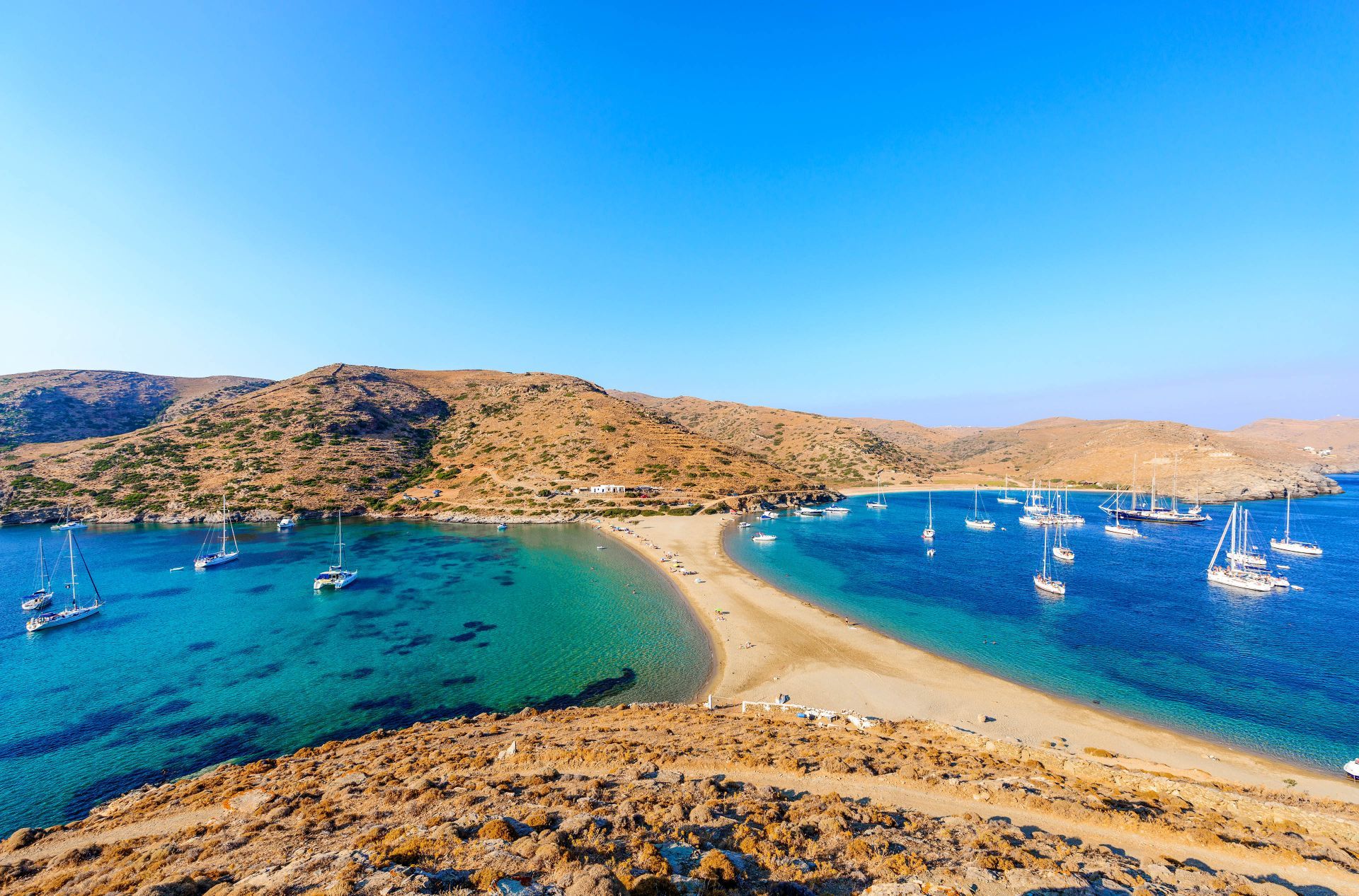
Kythnos travel guide: practical tips, best beaches like Kolona, where to stay, food highlights, and sample 3-day or week itineraries to plan your island escape.
Kythnos Travel Guide: Discover Kythnos Island, Greece
Kythnos travel guide: whether you’re seeking quiet beaches, charming whitewashed villages, or authentic Greek island life away from the crowds, Kythnos is one of the Cyclades’ best-kept secrets.
In this guide, we share practical tips, the best things to do in Kythnos, Greece, where to stay, what to eat, and how to build itineraries that balance relaxation and exploration. We’re local-guided travel specialists at Greece Tours, and we’ll walk you through getting to the island, must-see beaches like Kolona, hidden coves, boat experiences, and how to make the most of every hour on Kythnos.
The tours below hike the old trails of Kythnos, paddle to Kolona, visit a beekeeper and sail from Lavrio.
Kythnos At A Glance
Kythnos sits in the western Cyclades, a short ferry hop from the more famous islands but a world apart in atmosphere. With rugged hills dotted with windmills, small whitewashed settlements, and more than 100 beaches, Kythnos feels intimate and unhurried. Its main ports are Merihas (the ferry port) and Kythnos’ picturesque main town, Chora (also called Messaria). The tiny thermal springs at Loutra, a pastel-hued seaside village, are a major draw for visitors seeking thermal baths and wellness.
Why visit Kythnos? We love Kythnos for its balance: accessible from Athens and nearby islands, yet still off the main tourist radar. Beaches range from long sandy stretches to tiny rocky coves: walking trails link traditional villages, and local tavernas serve home-cooked food you won’t easily find in high-season hotspots. If your travel goals include snorkeling, quiet beaches, romantic sunsets, and authentic village culture, this island rewards patient exploration.
Quick facts
- Region: Western Cyclades
- Main ports: Merihas (ferry port), Chora (Messaria), Loutra
- Population: ~1,500 permanent residents (varies seasonally)
- Language: Greek (English widely spoken in tourist areas)
- Currency: Euro
This Kythnos travel guide will help you plan transport, activities, and where to stay so you can experience the island like a local.
Where is Kythnos, and how is the island laid out?
Kythnos lies in the western Cyclades between Kea and Serifos, 104 km from Piraeus and 49 km from Lavrio. Chora sits inland, Dryopida lies in the south, the port of Merichas faces west, Loutra faces north-east and Mount Kakovolo rises to 356 metres.
The Municipality of Kythnos covers the island and the islets around it, and it belongs to the South Aegean Region. Kythnos measures about 99.4 square kilometres, and its shoreline runs for about 104 kilometres. The 2021 census counted 1,568 permanent residents. By sea, the island sits 56 nautical miles from Piraeus and 25 nautical miles from Lavrio.
The Municipality of Kythnos gives the crossing as 3 hours from Piraeus and 1 hour and 40 minutes from Lavrio. Ferries run almost every day to both ports and to Ermoupoli on Syros, the capital of the Cyclades. Boats also link Kythnos with other islands of the western Cyclades, and travellers already on Milos can follow the Milos to Kythnos ferry route.
Chora, the capital and seat of the municipality, stands inland in the centre-north of Kythnos. It climbs a hillside in tiers, 8 km from Merichas, and the 2021 census recorded 621 residents there. Its second name, Messaria, refers to its inland position, and its people are also called Messariotes.
Dryopida, the second inland village of Kythnos, lies in the south, 7 km from Chora. It stands between two hills at 190 metres and cannot be seen from the sea; local tradition says it was built there to hide from pirates. Locals still call it Chorio or Syllakas, and its people are the Syllakotes. Clay tiles cover its slanted roofs, a habit brought home by villagers who worked in the tile kilns of Athens. Dryopida has been a listed traditional settlement since 1978 and had 399 residents in 2021.
Three coastal settlements complete the map of Kythnos. Merichas, on the west coast, is the main port and had 369 residents in 2011; one explanation ties its name to heather or tamarisk. Loutra, on the north-east coast, lies 5 km from Chora and 11 km from Merichas, and it served as the main port before Merichas grew. Kanala, on the south-east coast, stands on a cape between the beaches of Antonides, Ammoudaki and Megali Ammos, 12 km from Merichas and 5 km from Dryopida.
- Highest point: Mount Kakovolo, 356 metres, on the north-west side of Kythnos, crossed today by hiking paths.
- Kolona: a sand tombolo about 240 metres long and 80 to 100 metres wide that joins the islet of Agios Loukas to Kythnos.
- Apokrousi: a coastal hamlet in the north-west, 4.4 km from Chora and 9.4 km from Merichas.
- Climate: a mean annual temperature of 19°C and about 600 mm of rain a year, one of the highest totals in the Cyclades.
- Wind: strong north winds cross Kythnos, yet its climate has the name of a healthy one.
Kolona lies north of Merichas, opposite Apokrousi beach, inside the Natura 2000 zone of Kythnos. The sand strip runs north to south with a slight lean to the east, and it takes its name from its column-like shape. Boats reach it from the sea, and a dirt road leads to it from Apokrousi. Walkers follow the path to the ancient site of Vryokastro, descend to Apokrousi and continue to Kolona.
Why are the hot springs of Loutra on Kythnos famous?
The springs of Loutra gave Kythnos its old name, Thermia. Two springs rise there: Agioi Anargyroi at 38°C inside the spa, and Kakkavos at 52°C, which runs straight into the sea. A spa building designed by Christian Hansen was completed in 1857.
The warm water explains the second name of Kythnos. Nilos Doxapatris recorded the island as Thermia in 1143, and the Turks later called it Hamam Antassi, the island of warm waters. Italians used the form Fermina. The village name Loutra means the Baths, after the bath buildings set over the springs.
Loutra sits on the north-east coast of Kythnos, and people have lived there since antiquity because of its drinking water and natural harbour; the Mesolithic site of Maroulas lies close by. The 2011 census counted 81 residents, who work in tourism and fishing. The village began to grow in the 1980s, and the hot water still rises in the bay of Loutra, the source of the Thermia name of Kythnos.
Both springs at Loutra formed through post-volcanic activity. Agioi Anargyroi flows up inside the hydrotherapy building. It is a saline spring with more than 15,000 mg of dissolved solids per litre, mainly chlorine and sodium, and it shows moderate radioactivity of 25 Mache. Kakkavos rises 50 metres away. It is an iron-bearing saline spring with sodium iodide, sodium bromide and sodium chloride, and its radioactivity is weak at 4.1 Mache.
Finds around the springs date their use to Roman or Byzantine times: a brick bathtub fed by a channel from Agioi Anargyroi, five graves and a small glass vessel. A 4th-century BC relief in the Archaeological Museum shows a local hero receiving Asclepius and suggests a sanctuary at the springs.
In 1782 the local architect Konstantinos Zanakis built a vaulted pool and a changing room at Agioi Anargyroi. The community of Messaria paid for the work, and Nikolaos Mavrogenis, interpreter of the Ottoman fleet, oversaw it; an inscription set into the wall records his name. Islanders left the water of Kakkavos unused. They believed the devils of hell worked below the springs and that Kokkina, the spot where the hot water rises, was a home of fairies. They used the springs only to wash and tread hand-made woollen blankets and carpets.
- Chemical tests: analyses in 1830 and 1833 proved the healing value of the Kythnos springs.
- German experts: doctors and chemists who came to Greece with King Otto first recognised the therapeutic value of the water.
- Royal design: the architect Christian Hansen came to Kythnos in 1836 and drew the spa complex with his assistant Laurent.
- Building works: the reservoir at Agioi Anargyroi was built on scientific lines in 1838, and Laurent began the spa buildings in 1839.
- Neoclassical wing: Ernest Ziller designed the tile-roofed building next to the original spa, added in the years after 1857.
- Royal guests: King Otto and Queen Amalia bathed at Loutra during their reign, from 1837 to 1862.
Hansen did not build the complex himself, because he was designing the University of Athens at the time, so Laurent carried out the plan. The bathhouse keeps marble tubs for bathers, and the area is also known for its Xenia Hotel. Loutra gained electricity in 1932 through a donation from the Kanellopoulos family, and today it has a marina and a fishing shelter. A borehole at Loutra gives drinking water within accepted limits, unlike much of Kythnos.
What lies underground and in the wild on Kythnos?
Katafyki cave lies at Fyres in Dryopida, with more than 600 metres of mapped natural passages and a 2,000-metre mine gallery. Above ground, the Natura 2000 zone of north-west Kythnos covers 29.04 square kilometres of thorny scrub, juniper, seagrass and sea caves.
Katafyki sits on the southern edge of Dryopida, 190 metres above sea level, and the lanes of the village lead straight to it. Its name comes from its use as a refuge in times of piracy, Frankish and Ottoman rule and the Second World War. The cave also carries the name Giorgos Martinos Cave, after the Kythnian geologist who studied it. The German naturalist Fiedler came to Dryopida in 1841 to explore it.
Water from an ancient torrent carved long tunnels, and the rock stands in layers of schist and marble. The passages cover an estimated 3,500 square metres. Two corridors lead to the stalactite hall, which measures 25 by 17 metres. Its formations carry names such as the jellyfish, the octopus, the teddy bear and the embryo, and a large stalagmite is called the Tower of Babel. In another chamber, water collects between stalactites and stalagmites in a basin known as the trough.
Katafyki also served as an iron mine for hematite, and blasting destroyed a large part of its decoration. The cave is lit, its temperature is 17°C, and visitors follow a circular route past old rails and wagons. The Municipality of Kythnos manages it and reopened it in July 2015 after a two-year closure for safety reasons.
The Natura 2000 zone covers the north-west part of Kythnos, from sea level to the summit of Kakovolo. Its 22 km coastline is irregular, with small bays and sea caves. Kolona sits inside this zone, and a sea kayak tour of Kythnos reaches it from the water.
- Protected status: a Special Area of Conservation named Northwest Kythnos: Mount Atheras – Cape Kefalos and Coastal Zone, about 25% of it sea.
- Habitats: 18 habitat types, among them Mediterranean temporary ponds and Posidonia seagrass beds, both priority habitats.
- Plants: Silene cythnia, Fritillaria obliqua subsp. tuntasia, Anthyllis aegaea, Campanula laciniata and Muscari pulchellum subsp. clepsydroides.
- Marine life: the Mediterranean monk seal, bottlenose and common dolphins, the loggerhead turtle Caretta caretta and the fan mussel Pinna nobilis.
- Reptiles and amphibians: the leopard snake Zamenis situla, the terrapin Mauremys rivulata, the green toad Bufotes viridis and Erhard’s wall lizard Podarcis erhardii.
Fritillaria obliqua subsp. tuntasia grows only in the western Cyclades, on Kythnos, Gyaros and Serifos, and the Red Data Book of rare and threatened plants of Greece lists it as Vulnerable. Silene cythnia grows only in the Cyclades and on islands of the eastern Aegean. The monk seal uses the sea caves of the protected coast as shelter; in Greece it is listed as critically endangered. The loggerhead turtle is listed as endangered in Greece and as vulnerable worldwide by the IUCN. Other reptiles recorded on Kythnos include the cat snake Telescopus fallax, the whip snakes Platyceps najadum and Dolichophis caspius, the geckos Hemidactylus turcicus and Mediodactylus kotschyi and the green lizard Lacerta trilineata, along with the Balkan frog Pelophylax kurtmuelleri.
Phrygana of thorny burnet, Sarcopoterium spinosum, is the largest habitat in the zone, with Centaurea spinosa among it. Phoenician juniper and mastic form tall scrub, tamarisks line the beaches, and Posidonia meadows grow offshore. An extensive network of dry-stone walls shelters snakes, lizards and molluscs. Trees are scarce on Kythnos: eucalyptus and pine grow on the south-east side of Merichas, and the only pine forest of Kythnos stands on the Kanala peninsula around the church of Panagia Kanala. At Aghios Dimitrios, on the southern tip, sea daffodils dot a wide beach.
What do the Mesolithic site of Maroulas and ancient Vryokastro reveal about Kythnos?
Maroulas, on the northeast coast of Kythnos, holds stone-paved round huts and 26 burials dated between 8800 and 8600 BC, the oldest settlement found in the Aegean islands. Vryokastro, the ancient city of Kythnos, yielded an unplundered temple with over 1,400 offerings.
The Maroulas site sits on the shore just outside Loutra. Surveyors marked it as a pre-Neolithic settlement in 1975, yet the claim stayed in dispute until the first field study in 1995. The University of the Aegean and the 21st Ephorate of the Cyclades then dug 2,500 square metres between 2001 and 2005, on the initiative of the archaeologist Adamantios Sampson. Local quartz made up 80% of the stone tools. Obsidian from Milos supplied 16.8%, proof that hunter-gatherers on Kythnos already crossed the sea by boat. The same pair of islands meets again in the guide to Milos vs Kythnos.
The huts were round, 3 to 4 metres across, with floors paved in stone. Sea level stood 40 to 60 metres lower in the Mesolithic, so the camp lay inland, and part of it escaped the rising water. Bones of pigs, hares, foxes and birds lie beside tuna remains and shells. The birth season of the pigs and the tuna catch show that people stayed at Maroulas at least from mid-winter to late spring.
Herodotus records that the Dryopes, a pre-Greek tribe from the Mount Parnassus area, reached the islands in the 13th century BC, first Euboea and then Kea and Kythnos. Kythnos became one of their six main seats, beside Hermione, Asine, Styra, Karystos and Cyprus, and the island took its name from their mythical king Kythnos, a son of Apollo. The neighbouring island on that route is the subject of a Kea day trip from Athens.
Vryokastro, also called Rigokastro, stands on the northwest coast of Kythnos between the bays of Merichas and Apokrisi. Surface surveys from 1990 to 1995 revealed its town plan, and the finds show continuous life from the 10th century BC to the 6th or 7th century AD. Professor Alexandros Mazarakis-Ainian of the University of Thessaly leads the digs.
- Intact sanctuary: On 19 December 2002 the team announced an adyton found unplundered, with every offering in place. Over 1,400 objects came out, from jewels and gold, silver and bronze pieces to terracotta figurines and painted vases, dated mainly to the 7th to 5th century BC.
- Twin temple and altars: Two built altars stand beside a twin temple of the early Archaic age, the 7th century BC. Evidence points to Apollo and Artemis, although the cult remains uncertain.
- Sanctuary of Demeter: A shrine on the acropolis summit served from the late 8th century BC to the 1st century AD. Clay figures of women and children tie it to Demeter.
- Harbour at Mandraki: Underwater work since 2005 has traced a breakwater over 100 metres long. In 2008 and 2009 the seabed dig uncovered a cuirassed torso of the 1st century BC and three herm stelae of the 2nd century AD.
- Upper City and Vryokastraki: A row of buildings 800 metres long, read with caveats as temples, was dug from 2016 to 2018. On the islet of Vryokastraki, work from 2018 to 2020 found the first three-aisled Early Christian basilica on Kythnos.
Herodotus notes that the island sent a trireme and a penteconter to the Battle of Salamis in 480 BC, and Delphi recorded the gift on the base of a golden tripod. Aristotle wrote a study of the Kythnian constitution, now lost. The painters Timanthes and Cydias were born on Kythnos. In 202 BC Philip V of Macedon placed a garrison there, and after the fall of Andros in 199 BC a long Roman siege failed against its walls.
The finds now fill the Archaeological Museum of Kythnos in Chora, opened in 2023. It occupies the old single-classroom primary school, a neoclassical building designed by the civil engineer Dimitrios Kallias in the late 19th century. The museum idea dates to a 1994 conference on Kea and Kythnos organised by Lina Mendoni and Mazarakis-Ainian.
What happened on Kythnos from the Middle Ages to modern times?
Kythnos moved its capital to the cliff fortress of Kastro tis Orias in the 7th century AD, passed to the Duchy of the Archipelago in 1207, fell to the Ottomans in 1617, joined the 1821 revolution and lost people when its iron mines ran out.
In the 7th century AD the people of Kythnos withdrew to Kastro tis Orias, also called Katakefalos, on the north headland. Cliffs drop 150 metres to the sea on three sides, and a thick wall closed the fourth. The rough-stone town never held more than 500 people at its peak. Its church of Agia Triada keeps the only surviving frescoes in an old church on Kythnos.
In 1207 Kythnos joined the Duchy of the Archipelago of Marco Sanudo, and in this period it was known as Thermia. The Gozzadini family of Bologna later ruled it as lords, and Angelo I Gozzadini married Caterina Crispo, sister of the sixteenth Duke, in 1429. After depopulation in the early 15th century, Albanian families moved over from Euboea and merged with the Greek population. In 1600 Thermia became the name of a Latin bishopric.
The Ottoman fleet of Hayreddin Barbarossa sacked Kythnos in 1537. Local tradition says the people then left the Kastro and built a new inland capital, Messaria, around a second church of Agia Triada. The last Gozzadini lord, Angelo III, lost a siege to the Ottomans in 1617. An island ballad claims a woman in feigned labour pains tricked the guard’s daughter into opening the gate.
- 1672: The French corsair Hugues de Creveliers raided Kythnos, enslaved residents and looted local relics.
- 1770: Russian forces held the island for four years under a commissioner and four syndics, then left with ancient finds.
- 1791: A Greek school opened in the monastery of Panagia tou Nikous, first taught by the monk Parthenios Koulouris from Sifnos and from 1809 by Makarios Filippaios of Kythnos.
- 1806: A pirate raid, though beaten off, pushed families to emigrate to the Asia Minor coast; those who returned brought new customs.
During the 1821 revolution Kythnos sheltered refugees from Chios, Psara and Aivali. Moschos Filippaios of Chora and N. Economidis Levantis of Dryopida represented the island at the Third National Assembly.
King Otto used Kythnos as a place of exile for political opponents. In late February 1862 Captain Nikolaos Leotsakos seized the ship Karteria at Syros with 30 soldiers and sailed to free the exiles. On 1 March government troops cornered the rebels near the cove of Agia Irini, and Leotsakos, Periklis Moraitinis and the student Agamemnon Skarvelis died. The revolt, called the Kythniaka, marked the start of Otto’s fall, and older islanders still sing about it.
In the 19th century mines on Kythnos worked with companies in Lavrio, and iron ore found at the start of the 20th century gave islanders wages. Barley was the other export: before the war it reached half a million okades, bought mainly by the Fix brewery. The mines were worked out by the Second World War, and the iron mine at Katafyki closed in 1939. Young people left for Athens and beyond, and the population fell.
The German scholar Xaver Landerer put Dryopida at around 1,300 people in 1835, and Iakovos Rizos Rangavis gave 1,720 in 1854. A new mole in 1974 gave ferries a deep-water dock, and in 1982 Kythnos received the first wind park in Greece, with five turbines of 20 kW each.
Which churches, crafts and festivals does Kythnos keep?
Kythnos keeps around 130 country chapels, the 1575 icon of Panagia Kanala by Emmanouil Skordilis, the 1613 church of Agios Savvas in Chora and the carved screen of Agios Minas in Dryopida, plus a pottery trade, the Thermiotikos balos dance and an Easter Monday swing.
Agia Triada in Chora is the oldest church on Kythnos, a single-aisle vaulted basilica with a dome. The prelate Bartholomaios Deangelis painted it in the 17th century, and its feast falls on Pentecost. An inscription over the door of Agios Savvas gives its building year, 1613.
In Dryopida, Agios Minas holds a wood-carved iconostasis, 16th-century icons and a bishop’s throne of folk craft. Father Konstantinos Gonidis set up the Ecclesiastical and Byzantine Museum inside the church of Agios Georgios there. A Bavarian decree closed the monasteries of Kythnos in 1833, and Agios Ilias on the highest hill served as a German lookout in the Second World War.
Panagia Kanala is the patron saint of Kythnos. Tradition says fishermen pulled its icon from the strait between Kythnos and Serifos. The Cretan-school panel measures 1 m by 0.80 m. The present church went up in 1869, and the Holy Synod named it a pilgrimage site in 1973. Kostis Palamas wrote the poem The Three Sisters about Kanala, Stratilatissa and Flampouriani, three Virgin churches that, by tradition, the people of Dryopida built in sight of each other.
- 15 August: Panagia Kanala holds the main feast, with a procession and a re-enactment of the icon’s discovery at the pier, where priests throw a copy of the icon into the sea and swimmers dive for it.
- 23 August: Panagia Flampouriani, built in the mid-17th century on the edge of a rock, celebrates with lute and violin players singing Thermia songs.
- 2 November: Merichas honours the Five Martyrs at Agioi Akindynoi, guardians of the port and its ships, in one of the biggest feasts of Kythnos.
- Easter Monday: A large swing goes up in a Chora square, and young men and women in costume ride it; a couple on the swing pledges to marry.
- Carnival: Chora parades Lazanis, a straw figure who plays King Carnival, and on Tsiknopempti the young people of Dryopida dance the balos in the lanes to the sound of the tsampouna.
Music on Kythnos comes from the zya, a pair of violin and lute. The Thermiotikos balos is a couple dance in three parts, the stroto, the patito and the voltes, in which partners spin back to back with both hands joined. The karsilamas, with Asia Minor roots, is danced only by men facing each other.
Pottery and tile-making flourished in the 19th century. Craftsmen from Kythnos worked the Athens kilns each summer and came home in winter, and the Dryopida workers brought back the habit of tiled roofs. Clay ware still sells among household products of Kythnos, next to pasteli, served at Thermia weddings. The Folklore Museum of Dryopida, in a listed house behind Agioi Apostoloi, shows farm tools, weavings and the xotaris costumes.
Practical Information And Arrival
Getting basic logistics right makes a huge difference on a small island like Kythnos. Below, we outline how to reach Kythnos, the best times to visit, how long to stay, and how to get around once you’ve arrived.
Top Things To Do On Kythnos
Kythnos offers a mix of relaxed beach days, cultural discoveries, and active outdoor pursuits. Below are our top picks for things to do in Kythnos, Greece, activities we’d personally plan into any trip.
Best Beaches And Hidden Coves
With more than 100 shoreline spots, Kythnos is a beach-lover’s dream. Below, we highlight the must-visit beaches and lesser-known coves where you can find tranquility.
Where To Stay On Kythnos
Kythnos offers accommodation for couples, families, and independent travelers, boutique hotels, family-run guesthouses, and campsites. Below we break down options by style and budget, with suggestions that align with the vibe you’re after.
Food, Drink, And Local Experiences
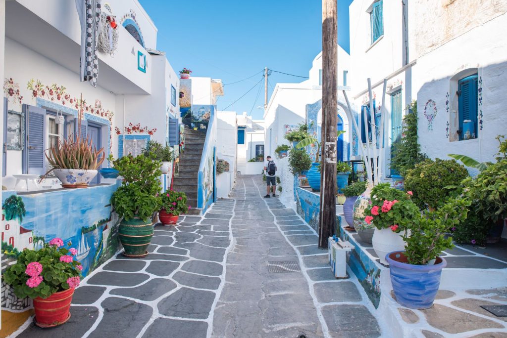
Kythnos’ cuisine is honest and seasonal. Locally produced olive oil, cheeses, honey, and fresh seafood form the backbone of the island’s food scene. Below, we highlight must-try dishes, tavernas worth visiting, and ways to deepen your culinary knowledge on the island.
Tours, Excursions, And Boat Activities
Kythnos’ best experiences often involve the sea. Below, we outline private boating options, snorkeling and diving, guided hikes, and trusted local operators.
From the water, a Kythnos kayak tour paddles to the Kolona sandbar, sea caves, hot springs that meet the sea and coves that no road reaches.
Sample Itineraries
To help you plan, here are three itineraries tailored to different trip lengths and interests. Each is designed for relaxed travel without cramming too much into your days.
Practical Tips, Safety, And Sustainability
Small islands require small acts of care. Below are practical packing, safety, and sustainability suggestions to keep your trip smooth and leave Kythnos as beautiful as you found it.
Conclusion
Kythnos is the kind of Greek island that rewards curiosity and slow discovery. Whether you’re searching for pristine beaches like Kolona, intimate village walks through Chora and Dryopida, or the restorative warmth of Loutra’s thermal springs, the island balances beauty with authenticity. Use this Kythnos travel guide to plan a stay that fits your pace. Three days will give you time to fall in love: a week will let you live like a local.
If you want a hand arranging local boat trips, farm visits, or a guided hike, we at MyGreeceTours specialize in small-group, locally led experiences that connect you with Kythnos’ hidden corners. Reach out, and we’ll help you craft an itinerary that matches your interests, whether that’s romantic sunsets, snorkeling coves, or off-grid village life. See you on the island.
Kythnos Travel Guide — Frequently Asked Questions
What makes Kythnos worth visiting compared to other Cyclades islands?
Kythnos offers quieter beaches, authentic village life, and over 100 varied beaches—from long sandy shores to hidden coves—plus thermal springs at Loutra. It’s easy to reach from Athens yet remains off the main tourist radar, ideal for snorkeling, hiking, and slow, local-focused travel.
How do I get to Kythnos, and which ports should I know?
Kythnos is a short ferry hop from nearby islands and Athens. Main ports are Merihas (ferry port), Chora (Messaria), and Loutra. Ferries arrive at Merihas; from there, you can taxi, rent a car, or take local buses to reach villages and beaches.
What are the must-visit beaches and natural attractions in Kythnos?
Don’t miss Kolona’s dramatic sandbar, numerous secluded coves for snorkeling, and Loutra’s tiny thermal springs. Rugged hills with windmills and walking trails between Chora and traditional villages add cultural and scenic variety to beach days.
When is the best time to visit Kythnos for good weather and fewer crowds?
For warm weather with fewer crowds, visit late spring (May–early June) or early autumn (September–early October). These shoulder months offer pleasant sea temperatures, open tavernas and services, and a more relaxed island vibe than peak July–August.
Can MyGreeceTours help arrange activities like boat trips and guided hikes on Kythnos?
Yes. Greece Tours specializes in small-group, locally led experiences on Kythnos, including private boating, snorkeling, guided hikes, and farm visits. Contact them to craft itineraries for romantic sunsets, off-grid village days, or snorkeling coves tailored to your interests.
Find more experiences in My Greece Tours:
- Patmos
- Paxi Antipaxi Tours: Explore Paxos and Antipaxos – Experience Paxos Tours & Antipaxos Tours
- Pelion Greece: The Ultimate Pelion Travel Guide
- Poros
- Rhodes Private Tours: Explore Rhodes Destinations & Attractions | Rhodes Greece Excursions & Tours
- Samos Dream Tours: Explore Samos Tours, Excursions & Samos Greece Experiences
- Santorini Greece Travel Guide: Best Things To Do in Santorini