
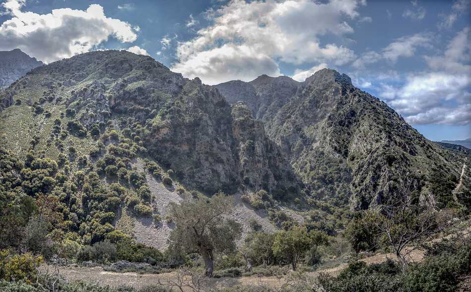
Thripti is one of the quietest corners of eastern Crete, a tiny stone village perched high in the Thripti mountain range at around eight hundred metres above the sea. It sits in the Lasithi district between Ierapetra and Sitia, wrapped in pine forest, cypress and terraced fields that stay cool and green while the coast below bakes through summer. A cluster of houses, a small church and a spring make up the settlement, with wide views over the plain and the Libyan Sea. Travellers who love solitude, forest air and mountain paths can plan the whole route with My Greece Tours.
This guide gathers what matters before you drive the rough mountain road up to the village. The sections below cover where Thripti sits, why its cool summer climate feels so different from the coast, the walks that climb from its doorstep, the produce that grows in its thin mountain air, and the practical way to reach it. Read it alongside our wider Crete travel guide to fit this remote peak into a longer eastern loop. Thripti rewards patience rather than speed, and a slow morning here trades resort crowds for pine shade, birdsong and enormous silence far above the busy shore.
Where is Thripti in Crete?
Thripti is a remote mountain village high in the Thripti range of eastern Crete, inside the Lasithi district between Ierapetra and Sitia. It stands at around eight hundred metres, above the Ierapetra plain and the Libyan Sea.
The village belongs to the wild interior of eastern Crete, well away from the resort strip along the south coast. It rests in the Lasithi district, the eastern administrative part of the island, on high ground that separates the town of Ierapetra on the Libyan Sea from Sitia further to the northeast. From the settlement the land drops sharply toward the Ierapetra plain, so the houses look out over a wide sweep of farmland and open water. The great cleft of the Ha Gorge slices into the mountain just below, and the peaks of the range rise close behind.
To reach it you leave the coast entirely and climb a rough road through pine forest, gaining height with every bend until the sea shrinks to a bright blue line and Thripti appears among the trees.
Position shapes the whole feel of the place. At eight hundred metres the village sits far higher than the beach towns, and the drive up marks a clear shift from coast to mountain. The route threads between terraced fields and pine forest, and the last stretch demands a careful hand on a narrow, stony surface that climbs bend after bend. For a base you would look to the town below, on the Libyan Sea shore, the natural gateway to this whole side of the range.
A day exploring the eastern highlands pairs the mountain village with the coastal life of Ierapetra, then loops onward across quiet, empty mountain roads toward the harbour and old quarter of Sitia further to the northeast, tying the wild interior to two very different coastal towns.
Why does Thripti stay cool and green while the rest of Crete bakes?
Height and forest keep Thripti cool while the coast bakes. At around eight hundred metres the air stays fresh, and pine, cypress and terraced fields hold moisture, so the village stays green through summer when the plain below turns dry.
Altitude does most of the work. Air cools steadily with height, so the village at eight hundred metres feels markedly fresher than the shore, where the summer sun beats down without shade. Around the houses grow pine forest and cypress, their canopies casting deep shade and slowing the loss of moisture from the ground. Terraced fields hold soil and water on the steep slopes, and the greenery lingers long after the coastal plain has faded to brown. A cold spring feeds the settlement, keeping gardens and orchards alive.
The result is a pocket of green mountain in a corner of Crete better known for its heat, a place where you reach for a light layer in the evening even at the height of the season.
This cool climate turns the village into a natural refuge from summer glare. Walkers who find the low ground punishing in high summer come up here for shade, birdsong and air that carries the sharp scent of pine resin. The forest paths stay usable through the hottest weeks, which sets the area apart from the exposed lowland trails baking near the coast. That contrast between roasting shore and green summit is a large part of the appeal, and it slots the village neatly into the list of things to do in Crete for travellers who prefer height to beach.
Morning is the finest time to arrive, when mist can hang among the pines and the whole range feels wrapped in cool, resin-scented quiet long before the sun warms the wide plain far below.
What walks start from Thripti?
Old footpaths climb straight from the village into the range. Routes reach the summit of Aforesmenos, cross toward the Katharo plateau, and descend beside the dramatic Ha Gorge, giving walkers forest, ridge and canyon views in one high area.
The village makes a fine trailhead for the eastern mountains. Old paths, worn by generations of shepherds and farmers, leave the houses and climb through pine toward the peaks of the range. One line heads for the summit of Aforesmenos, the high point above the settlement, rewarding the effort with a clear sweep over the Ierapetra plain and the Libyan Sea. Another crosses the high ground toward the Katharo plateau, a remote upland basin ringed by mountains. The great cleft of the Ha Gorge opens just below the village, its sheer walls forming one of the most dramatic sights of the district.
Together these routes give a walker forest, open ridge and deep canyon within a single compact area, all reached on foot from the same cluster of stone houses.
These are proper mountain walks, so they ask for sturdy boots, water and an early start rather than casual sandals. The paths trade cool shade for open ground, and the higher lines expose you fully to sun and wind out above the trees. The reward is solitude of a kind hard to find near the coast, with huge views and the fair chance of meeting nobody at all for hours on end. The Ha Gorge itself is a serious canyon best admired from safe ground unless you are equipped for a technical descent.
For anyone building a walking itinerary in the east, the village anchors a compact cluster of routes and pairs naturally with wider hiking in Crete, linking deep pine forest, a bare high summit and one of the island’s boldest gorges.
What grows around Thripti in the cool mountain air of eastern Crete?
Cool height suits fruit and nut trees that struggle on the hot coast. Walnut and chestnut trees, apples and cherries grow around Thripti, fed by the spring and terraced soil rare in this dry corner of Crete.
The thin, cool mountain air changes what the land can produce. Where the coast favours olives and early vegetables, the high ground around the village suits trees that need a colder season. Walnut and chestnut trees stand among the houses and along the terraces, and their nuts ripen in the crisp autumn air. Apple and cherry trees grow in the same cool climate, fruit that would struggle in the heat of the plain below. The cold spring and the moisture held by the forest keep these orchards alive through summer, and terraced fields catch soil and water on the steep slopes.
This green, fruitful character sets the settlement apart from the dry, sun-scorched farmland far beneath it and gives the mountain a soft, cultivated edge among the wild pine. Higher still, the great pine expanse of Selakano forest spreads across the Dikti slopes nearby.
This produce tells you a great deal about the place. A village that grows chestnuts and cherries in eastern Crete is a village that stays cool and moist when everywhere below has dried to brown, and that single fact explains its quiet charm. Terraced plots, fruit trees and pine forest weave together into a living, working mountain landscape rather than an abandoned ruin. Walkers passing through in late summer or early autumn may spot ripening fruit and gathered nuts, small signs of a life tuned closely to the highland seasons.
This rich blend of forest, orchard and enormous view is exactly why the village turns up on lists of hidden gems in Crete, a cool green pocket most visitors to the busy south coast never reach or even hear about.
How do you reach Thripti and who is it for?
A rough mountain road climbs to Thripti from the villages below, best driven with care and a capable vehicle. It suits walkers and drivers exploring the wild interior of eastern Crete, seeking solitude and views rather than the beach.
Getting there is part of the experience. The village hangs high above the coast, and the only approach is a rough mountain road that climbs from the villages below through pine and terraced slopes. The surface turns narrow and stony on the upper stretches, so a careful driver and a capable vehicle make the ascent far more comfortable. There is no bus and no easy shortcut, which is precisely why the place stays so quiet. Most travellers set out from Ierapetra on the south coast, the natural gateway to this side of the range, and give the drive the time it deserves rather than rushing.
The reward at the top is a cluster of stone houses, a church, a spring and an outlook over the Ierapetra plain and the Libyan Sea that few visitors to Crete ever see.
The village is not for everyone, and that is exactly its strength. It rewards travellers after solitude, forest walks, mountain air and enormous views, far from the resorts and their crowds. It suits walkers and drivers keen to explore the wild interior of the east rather than sunbathers chasing a beach. Bring water, fuel and sturdy shoes, plan the outing around the daylight, and treat the day as a slow mountain journey rather than a quick photo stop. Pair the drive with the deep cleft of the Ha Gorge just below the village for one of the boldest landscapes in the whole district.
Travellers drawn to the high, empty, forested side of the island will find this remote, silent peak a rare and lasting memory.
Frequently Asked Questions
Is Thripti worth visiting on a Crete trip?
Thripti is worth the climb for travellers who value quiet, height and forest over beaches and resorts. The village sits at around eight hundred metres in the eastern mountains, staying cool and green right through summer while the coast bakes far below. You reach a small cluster of stone houses, a church and a cold spring, with wide views over the Ierapetra plain and the Libyan Sea and old footpaths climbing steeply into the range. It is not a place of tavernas and sights ticked off a list, but a place of deep pine shade, clean mountain air and enormous silence high above the shore.
Walkers, drivers and anyone curious about the wild interior of the east will find it richly rewarding, though sunseekers set on a beach day will not. A green mountain refuge above a hot coast earns its place on an eastern loop through Crete, well away from the coastal crowds and the resort strip.
How long should you spend at Thripti?
Plan at least half a day around Thripti, and a full day if you intend to walk. The rough mountain road up from the coast takes real time, and rushing the narrow, stony upper stretches spoils both the drive and the safety of it. At the village itself, an hour of quiet, a look at the church and cold spring, and a slow gaze over the Ierapetra plain fill a gentle morning nicely. Walkers should budget far longer, as the paths toward the summit of Aforesmenos or across to the Katharo plateau are genuine mountain routes that ask for an early start and steady legs.
A good number of travellers fold the village into a wider eastern day that also takes in the deep, dramatic cleft of the Ha Gorge just below the houses. Treat it as a slow, unhurried highland outing rather than a quick roadside stop, and the cool air and vast, uninterrupted views repay every extra hour you give it here.
What should you bring for a day at Thripti?
Pack for a remote mountain day rather than a beach outing. Carry ample water, as the village is high and the walks expose you fully to sun and wind out above the trees. Sturdy boots matter on the old paths and loose stony ground, and a light layer helps in the cool evening air even at the height of summer. Fill the fuel tank before you leave the coast, as there are no services on the rough road up, and drive the narrow upper stretches with care in a capable vehicle. Bring food, as the tiny settlement offers little in the way of shops.
Sun protection, a paper map or offline route and an early start round out the basic kit. Anyone planning to walk toward Aforesmenos or across to the Katharo plateau should treat the outing as a serious mountain hike and prepare well for changeable, exposed conditions high above the warm, busy shore below.