
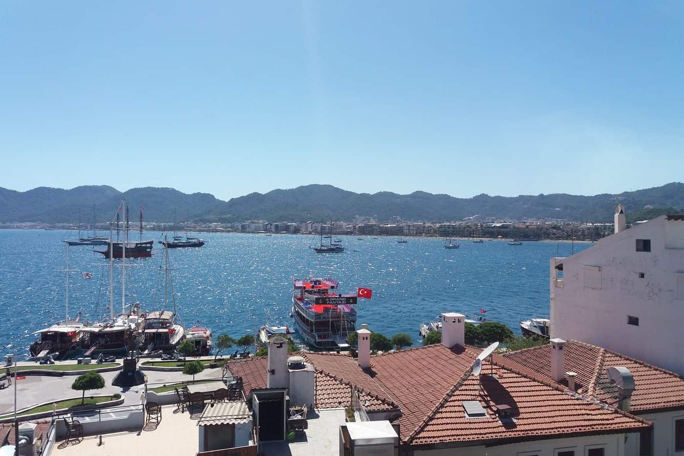
Marmaris tours start in the port town of Marmaris in Muğla Province on the south-west coast of Turkey, set on a wide bay ringed by pine-covered mountains, across the water from Rhodes. The routes cover the castle and the old town, the marina, boat trips around the bays, Cleopatra Island, Dalyan and the Kaunos rock tombs, the Bozburun and Datça peninsulas and Pamukkale. Greece Tours lists the day trips that cross to Marmaris from Rhodes.
This page covers what Marmaris tours see in the town and at sea, which day trips reach the peninsulas, Dalyan, Pamukkale and Fethiye, how visitors reach Marmaris from Rhodes and Dalaman, and which season suits each route. The tours below are checked on GetYourGuide and Viator and leave from Marmaris and Rhodes.
What do Marmaris tours cover?
Marmaris tours cover the port town of Marmaris in Muğla Province, Turkey: the castle museum, the old town lanes, the marinas, the covered Grand Bazaar and the story of ancient Physkos, plus hiking and mountain biking trips into Marmaris National Park.
Marmaris is a municipality and district of Muğla Province, with an area of 906 km2 and 97,818 residents in 2022. The town lies on the Mediterranean shore of the Turkish Riviera, between two intersecting sets of mountains, and ferries link it with Rhodes and Symi. Visitors staying on Rhodes join Marmaris tours on a Marmaris day trip from Rhodes.
Marmaris National Park, established on 30 January 1996, covers 33,350 ha of the district. Marmaris tours into the park offer hiking, trekking, mountain biking, botanical tours for endemic plants and wildlife observation. Günnücek is the easiest entry point, a rugged tract of pine forests with hiking trails.
- Forest: Turkish pine (Pinus brutia), with the endemic sweetgum tree in deep, moist soils.
- Plants: 514 species identified in the park, 54 of them endemic.
- Wildlife: 112 bird species, 21 mammal species and the endangered wild goat (Capra aegagrus).
- Ruins: the Carian settlement of Amos, with city walls, an amphitheatre and a temple.
What do Marmaris tours see in the old town and the castle?
Marmaris tours in the old town climb to Marmaris Castle, which Suleiman the Magnificent rebuilt in 1522 and which opened as a museum in 1991, then follow the waterfront of Barbaros Caddesi and the lanes down to Atatürk’s Statue, the focal point of town.
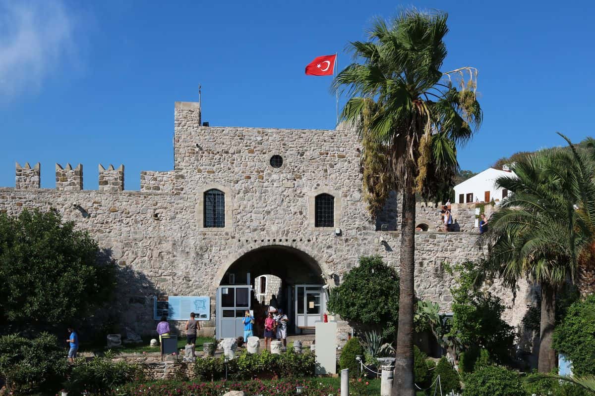
The castle overlooks the whole harbour area, and Marmaris tours visit it as one of a small group of Turkish castles that also hold a museum. Renovation began in 1979 under the Ministry of Culture, and the fort was registered as a monumental structure in 1983. The only known written source on its construction is the Seyahatname of the Ottoman traveller Evliya Çelebi, who visited Muğla in the 17th century.
A French warship destroyed an important part of the castle during World War I. Below the walls, Barbaros Caddesi runs along the old town waterfront under the nickname Bar Street. Marmaris tours end the old town walk at Atatürk’s Statue, the junction of Atatürk Caddesi on the beachfront and Ulusal Egemenlik Caddesi through downtown.
- Galleries: seven of them, the largest used as an exhibition hall.
- Courtyard: an open space full of seasonal flowers.
- Old quarter: 18 residences, a fountain and a cistern, home to locals until 1979.
- Harbour light: a small tower south of the castle, shaped like a sentry box.
What do Marmaris tours see at the marina and the bazaar?
Marmaris tours at the waterfront pass the yacht harbour below the castle, the ferry terminal and the marinas, then turn inland to the covered Grand Bazaar, which starts 50 m from Atatürk’s Statue and holds a small Ottoman caravanserai built by Süleyman’s mother.
Marmaris is a centre for sailing and diving, with two major marinas and smaller ones, and it serves as a wintering location for hundreds of cruising boaters. The town is a Port of Entry into Turkey, so yachts arriving from Greek waters clear immigration and customs here. Marmaris tours along the quay also meet the gulets of a major centre for traditional gulet cruises and luxury yacht charters.
The ferry terminal stands on the east side of the marina, and the harbour footbridge puts the castle and downtown 1 km away on foot. The Grand Bazaar is a covered market along 59th Sokak, a modern alley that is practical rather than scenic. Its caravanserai, built by Ayşe Hafsa Sultan at the same time as the castle, stands just north of the fortress and is closed to visitors.
Marmaris tours through the market warn against buying tortoises and other animals from sellers, since importing endangered species brings a hefty fine.
- Marinas: Netsel Marina, Marmaris Yatmarin, Albatros Marina and Martı Marina.
- Diving: scuba centres clustered round the harbour.
- Pharmacies: a cluster along Ulusal Egemenlik Caddesi, the main downtown street.
- Hamams: traditional Turkish baths in half-a-dozen locations in town.
What history do Marmaris tours tell?
Marmaris tours tell a history that runs from ancient Physkos, a Carian harbour town belonging to Rhodes, through Suleiman the Magnificent’s campaign of 1522 and the British fleets of 1798 and 1801, to the 1957 earthquakes that left only the castle quarter standing.
Marmaris tours start the story in the 6th century BC, when the site was known as Physkos, with a harbour and a grove sacred to Leto. Research in Nimara Cave, at the highest point of Heaven Island, revealed a cult of Leto, mother of Apollo and Artemis, in ancient Physkos. In 334 BC Alexander the Great invaded Caria and besieged Physkos Castle, and the 600 inhabitants burned their valuables in the castle before escaping to the hills.
The name Marmaris dates from the Beylik of Menteşe and comes from the Greek màrmaron, marble, after the rich marble deposits of the region and the port’s role in the marble trade. Marmaris kept its Greek population until the end of World War I; after the population exchange that followed the 1919–1922 Greco-Turkish War, Turkish migrants from the Balkans settled the town.
Marmaris tours close with the 1957 Fethiye earthquakes: the first, on 24 April, measured 7.1, and the second, on 25 April, measured 7.3. The two shocks almost completely destroyed the city, and after a construction boom in the 1980s little remains of the sleepy fishing village.
- 1522: Suleiman launches his campaign against Rhodes from Marmaris, the base of the Ottoman navy.
- 1798: Admiral Nelson assembles his fleet in the harbour before the Battle of the Nile.
- 1801: a British force of 120 ships under Admiral Keith and 14,000 troops under General Abercromby anchors in the bay for eight weeks.
- 2018: archaeologists find the 2,300-year-old pyramid-shaped tomb of the boxer Diagoras near Marmaris.
Which boat trips do Marmaris tours run around the bays?
Marmaris tours run bay boat trips on a standard anti-clockwise loop via Turunç, the Phosphorus Cave and Cennet Island beach. Longer Marmaris tours start blue cruises on gulets, the two-masted or three-masted wooden boats built in Marmaris and Bodrum.
Marmaris tours at sea lean on the gulet, a traditional Turkish wooden boat that carries two masts on the common design. Gulets measure 14 to 35 metres and now run almost universally on diesel, and the Go Türkiye travel guide calls Marmaris a major centre for gulet cruises and luxury yacht charters.
Multi-day Marmaris tours follow the blue cruise, Mavi Yolculuk in Turkish, a week-long gulet voyage to ancient cities, harbours, tombs and beaches in the coves of the Turquoise Coast. Marmaris is a starting port alongside Bodrum, Fethiye and Antalya. The writer Cevat Şakir Kabaağaçlı, the Fisherman of Halicarnassus, made such trips on sponge divers’ gulets after his exile to Bodrum in 1925.
On the bay loop, Marmaris tours stop at Cennet Island, also called Heaven Island. The Phosphorus Cave on its south tip is a sea cave flooded with blue light, too narrow for boats and with no land access. Research in Nimara Cave, at the island’s highest point, revealed a cult of the goddess Leto, and the cave became a protected area in 1999.
The bay shore holds these sights:
- Turunç: a former fishing village 20 km south of Marmaris, with a Blue Flag award.
- İçmeler: a resort 8 kilometres southwest of Marmaris, directly across the bay from the port.
- Amos: ancient Carian walls 3 to 4 metres high on the hill of Asarcık, above the gulf of Marmaris.
- Marmaris National Park: a 33,350-hectare park declared on 30 January 1996, with Amos inside it.
Which Marmaris tours sail to Cleopatra Island?
Marmaris tours to Cleopatra Island, Sedir Adası in Turkish, head north of Marmaris to the Gulf of Gökova and cross by boat from Çamlı or Akyaka. The island holds the ruins of ancient Cedrae and a beach of tiny limestone spheres under strict protection.
Popular Marmaris tours by boat take in Sedir Island, commonly known as Cleopatra’s Island, for its soft and protected sand. It lies a short distance off the southern shore of the Gulf of Gökova, a 100 km gulf between the Bodrum and Datça peninsulas, and is the largest of a group of three islands.
Marmaris tours land on the site of Cedrae, or Kedreai, a city of ancient Caria. Lysander took the city because it was allied with the Athenians, and in the Hellenistic era Cedrae became one of the key demes of the Rhodian Peraea.
A boardwalk leads through the overgrown ruins, past a small and a large church from the Byzantine era. The site keeps a theatre, an agora, city walls with towers of cut stone and, near the summit, the foundations of a Doric temple.
Cleopatra Beach fills the cove on the northwest shore. Legend says ships brought its sand from the Red Sea for Cleopatra, while research links it to continual erosion of the sandstone bed on site. Each grain is a limestone sphere called an ooid, and the government protects the beach heavily to stop any sand being removed.
- Delian League: Cedrae appears in the tribute records of Athens from 454/3 to 415/4 BCE.
- Orata: the smaller island just north holds similar ruins.
- Necropolis: the mainland opposite the island holds constructed tombs and sarcophagi.
Which Marmaris tours go to Dalyan and the Kaunos rock tombs?
Marmaris tours to Dalyan ride river boats through the reeds of the Dalyan Çayı, past six rock tombs cut into the cliffs, to the ruins of Kaunos. The boats also reach İztuzu Beach, a loggerhead turtle nesting ground, and the riverside mud baths.
Dalyan, in the Ortaca district between Marmaris and Fethiye, takes its name from the Turkish for “fishing weir”. Life there revolves around the river, and Marmaris tours reach the local sites by boat, the preferred means of transport.
Kaunos, a city of ancient Caria, stands on the west bank of the river, which in antiquity was the Calbys, the border between Caria and Lycia. The growth of İztuzu Beach and the silting of the old Bay of Dalyan left the port about 8 km from the coast. Marmaris tours cross on a river ferry that runs on demand, then walk 500 m to the ruins.
The six rock tombs on the river date from the 4th to the 2nd century BC and are Dalyan’s prime sight. Their façades copy the fronts of Hellenistic temples, with two Ionian pillars and a triangular pediment. Known as the Tombs of the Kings, or Kral Mezarları, these Lycian tombs face the town from the sheer cliffs.
- Acropolis: a 152 m rock with Byzantine walls and views over the river and İztuzu Beach.
- Theatre: 75 m in diameter, with room for 5,000 spectators.
- Temples: six excavated, two Hellenistic and four Roman.
Marmaris tours bring day visitors to İztuzu Beach, a 4.5 km spit of sand between the Dalyan delta and the Mediterranean, known as Turtle Beach for its loggerhead sea turtle (Caretta caretta) nests. Building of the 1,800-bed Kaunos Beach Hotel began in 1987; conservationists led by June Haimoff and David Bellamy campaigned, and in 1988 the beach became part of the Köyceğiz-Dalyan Special Environmental Protection Area.
Marmaris tours land under strict rules in force since 1988: the beach closes to the public at night in the nesting season, parasols and sunbeds are banned in the marked nesting zones, and speedboats are banned on the river, in the delta and within 1 mile of the beach.
River boats also go upstream to Lake Köyceğiz, linked to the sea by the reedy Dalyan channel. Mud baths sit on the west riverbank near the north ferry crossing, and Sultaniye Spa on the lake’s south side pairs a 40 °C thermal spring with a mud bath.


Which Marmaris tours explore the Bozburun peninsula?
Marmaris tours to the Bozburun peninsula leave the Datça road at Hisarönü and head south through Orhaniye and Turgut to Selimiye and Bozburun, on a mountainous peninsula of 25 coves that lies 17 km north of Rhodes and 7.5 km east of Symi.
South of Hisarönü, Marmaris tours reach Orhaniye and its marina. The bay holds Kızkumu, a 600-metre strip of shallow water that divides the bay in two. Legend says a girl filled her skirt with sand to build a path to her lover across the sea and drowned when the sand ran out. A sculpture of the girl stands where the shallows begin.
Turgut, 5 km south of Orhaniye, is a quiet village known for the Turgut Şelalesi waterfall on its outskirts. Marmaris tours then reach Selimiye, a fishing neighbourhood of 1,308 people about 35 km from central Marmaris. Its families trace their roots to Razgrad in Bulgaria, its name honours the Ottoman sultan Selim I, and its Sığliman cove ranks among the leading yacht harbours of Turkey.
Marmaris tours also stop at Bozburun, a town of 2,238 people that lives from tourism, fishing, sponge diving and beekeeping; its thyme honey is famous across Turkey. Its yards build gulets on a par with Bodrum and Güllük, and Bozburun-built boats make up more than half of the yachts and gulets in Marmaris marina.
In antiquity the peninsula was Trakheia Khersonesos, the rocky peninsula, part of the Rhodian Peraia, the mainland territory of Rhodes. Marmaris tours with an ancient focus reach three Carian sites:
- Loryma: a fortified Rhodian port on Bozuk Bükü bay, 20 Roman miles from Rhodes, whose hilltop wall keeps sheer faces and precise corners.
- Kastabos: a 1st-century BC sanctuary of the demigod Hemithea with a temple and a theatre, found in 1960 by J.M. Cook and W.H. Plommer.
- Phoenix: a town 2 km south of Taşlıca, settled from the early 6th century BC, near Mount Phoenix, now Karayüksek Dağ.
Which Marmaris tours cross the Datça peninsula to Knidos?
Marmaris tours to Knidos run west along the narrow, 80 km Datça peninsula, pass Datça town at its halfway point and end at Tekir on the western tip, where the Dorian city of Knidos spread over the mainland and the island of Triopion.
Marmaris tours take the road from Marmaris to Datça, which is rough in parts. The peninsula joins the mainland at Balıkaşıran, a narrow isthmus at the head of the 1.5 km Bencik Cove, with the Gulf of Gökova to the north and the Gulf of Hisarönü to the south. Herodotus records that the Knidians tried to dig a canal here during the Persian invasions of 540 BC and surrendered after an oracle told them not to pierce the isthmus.
Marmaris tours stop in Datça, a district of 436 square kilometres and 25,029 residents whose name comes from Stadia, an ancient town near Knidos. The town has three quarters about a mile apart: Reşadiye, İskele (the quay) and Eski Datça (Old Datça). Eski Datça is the only neighbourhood on the peninsula lived in without a break since antiquity, with a history reaching back to the 11th century BC. The poet and Shakespeare translator Can Yücel is buried in Datça.
At Tekir, Marmaris tours walk a city just under a mile long. A causeway, now a 100 m-wide spit, joined Triopion to the shore and split the channel into two harbours, and the moles of the larger southern harbour stand in good part today. Excavators identified the agora, a theatre, an odeum and temples of Dionysus and the Muses. Knidos joined Lindos, Kamiros, Ialyssos, Kos and Halicarnassus in the Dorian Hexapolis.
Marmaris tours at Knidos visit three sacred and funerary monuments:
- Temple of Aphrodite Euploia: a circular Doric temple that held the naked Aphrodite carved by Praxiteles in 365 BC, found by Iris C. Love in 1969.
- Sanctuary of Demeter: a terrace laid out in 350 BC on the side of an acropolis, where C. T. Newton found the seated Demeter of Knidos.
- Lion monument: an 18-metre funerary monument three miles from the city whose six-tonne marble lion now stands in the British Museum.
Which Marmaris tours run jeep safaris in the hills?
Marmaris tours by jeep race across the Bozburun peninsula in summer, stop at the Turgut waterfall and pass beekeepers’ honey camps in hills of Turkish pine and sweetgum, the two trees that also shape the 33,350-hectare Marmaris National Park.
For Marmaris tours by jeep, the Turgut waterfall is the favourite stop. In the countryside around Turgut, beekeepers set up honey camps each summer and line up hundreds of beehive boxes. The camps feed the production of Marmaris honey, the honey the town is known for.
Marmaris tours through the pine hills cross pine-honey country. Muğla Province, home to Marmaris, accounts for 80% of Turkish pine honey, and Turkey produces 92% of the world’s supply. Bees make it from honeydew left by Marchalina hellenica, a scale insect that sucks the sap of the Turkish pine (Pinus brutia). Turks eat this çam balı at breakfast, drizzled over kaymak with bread.
Marmaris tours into the hills enter Marmaris National Park, declared on 30 January 1996, where Turkish pine forms the forest and the endemic sweetgum grows in deep, moist soils. Surveys list 514 plant species, 54 of them endemic, plus 21 mammal species and 112 bird species. A large stand of oriental sweetgum surrounds Marmaris, and its sap gives a balsam, sığla yağı, known in English as storax.
The park also holds:
- Wild goat: an endangered mammal of the region between Köyceğiz and Marmaris, found with the caracal, the bear and the wild boar.
- Amos: a Hellenistic town near Turunç whose walls stand 3–4 metres high and whose theatre seated around 1,300 people.
- Outdoor sports: orienteering, paintball, mountain biking, mud races and rock climbing inside the park.
Which Marmaris tours go to Pamukkale and Hierapolis?
Marmaris tours to Pamukkale head inland to Denizli Province, where hot springs built a white travertine hill 160 metres high. The ancient Greek spa city of Hierapolis stands on top, and UNESCO listed the pair together as a World Heritage Site in 1988.
The road for Marmaris tours leaves the coast to the north. Marmaris lies 60 km from Muğla, the provincial capital, and the D330 links Muğla with Denizli. Pamukkale sits 20 km north of Denizli, in the River Menderes valley of the Inner Aegean region. Our page on Pamukkale from Marmaris covers that single trip in full.
Pamukkale means “cotton castle” in Turkish, after its snow-white limestone. The travertine formation runs about 2,700 metres long and 600 metres wide. The area holds 17 hot springs between 35 °C and 100 °C, and their water travels 320 metres to the head of the terraces, where calcium carbonate settles as a soft gel and hardens into travertine. Marmaris tours join more than two million visitors who come each year.
Travertines and Hierapolis share one ticketed area with three gates. Tour coaches go direct to the South Gate, the main entrance for motorists, which opens straight into Hierapolis. Shoes are not allowed on the travertine, so visitors cross the one open cascade barefoot, and the rest of the terraces stay off-limits to protect them. Late spring and early summer suit Marmaris tours best, because the pools can run dry in late summer.
Hierapolis has served as a spa since at least the 2nd century BC. Marmaris tours inside the ruins reach these four sights:
- Theatre: built in 129 for a visit by Emperor Hadrian, with 50 rows of seats.
- Necropolis: about 1,200 tombs over more than 2 km, including the Tomb of Philip the Apostle.
- Cleopatra’s Pool: a thermal pool where ancient marble columns lie submerged.
- Museum: three vaulted halls of the Hierapolis Bath, with finds from Laodicea and Colossae.
Which Marmaris tours reach Fethiye and Ölüdeniz?
Marmaris tours to Fethiye follow the D400 east past Dalaman Airport to the Lycian coast. The day links the rock tombs of ancient Telmessos in Fethiye with the Blue Lagoon at Ölüdeniz, 14 km south, below the paragliding slopes of Mount Babadağ.
Ferries no longer sail from Fethiye to Marmaris, so Marmaris tours make the trip by road. The first leg covers 100 km east to Dalaman Airport through Gökova, Köyceğiz, Ortaca and Dalaman town, a 90-minute run for the airport shuttle bus. Fethiye lies one more hour along the D400, via Göcek.
Fethiye stands on the site of ancient Telmessos and took its current name in 1934, after Captain Fethi Bey, one of the first Ottoman Air Force pilots. The Lycians built the Tomb of Amyntas in 350 BC, part of the group of tombs carved into the cliffs on the south side of town. Kayaköy, the abandoned Greek village, lies 10 km south of Fethiye.
Ölüdeniz means “Dead Sea”, for its calm water even during storms, and its official translation is Blue Lagoon. The lagoon is a national nature reserve where construction is strictly prohibited, and its pebble beach is an official Blue Flag beach. Belceğiz, the sandy beach of the resort, is where paragliders prefer to land.
Paragliders launch from the cable-car top station on Babadağ, a limestone mountain whose main summit rises to 1,969 metres less than 5 km from the sea. Stable weather and that height draw pilots, and flights above water make Ölüdeniz a base for safety training and acrobatics. Beginners on Marmaris tours fly tandem, strapped in front of an instructor, for one hour.
Butterfly Valley, Kelebekler Vadisi in Turkish, sits at the foot of Babadağ. Marmaris tours reach it on the shuttle boat that runs hourly in daytime from Belceğiz Beach, 5 to 7 km away. Its butterflies show between June and September.
- Canyon: 3 to 4 km long, with steep walls 350 to 400 m high.
- Waterfalls: two small falls dropping from 60 m all year round.
- Butterflies: 105 species from 15 families, including the Jersey tiger.
- Protection: a first-category nature reserve since 8 February 1995.
Which beaches do Marmaris tours reach?
Marmaris tours reach the sandy town beach, İçmeler on its own bay 8 km southwest, Turunç 20 km south across the mountains, and the pebble shore of Akyaka, a 30-minute drive north. Kumlubük lies past Turunç on the Carian Trail.
Beaches and watersports bring the bulk of visitors to Marmaris. The resort runs south until it merges with İçmeler, and from there the road crosses the mountains to Turunç. Dolmuş minibuses with an orange band serve İçmeler, while the green-band ones stay inside Marmaris.
İçmeler is a neighbourhood of Marmaris with 6,735 residents, set on İçmeler Bay on the Datça Peninsula. Pine forests surround it on three sides, and the busy port of Marmaris faces it directly across the bay. The former fishermen’s and sponge divers’ village grew on visitors seeking a quieter alternative to Marmaris, which makes it a calm base for Marmaris tours.
Turunç lies 20 km south of Marmaris, surrounded by the Taurus Mountains, and the drive takes about 20 minutes on a road with a very low speed limit. The former fishing village of 1,939 residents measures about 1 km end to end, a half-hour walk, with restaurants, bazaars and bars on the waterfront. Its season runs seven months, from April to October.
Walking Marmaris tours can follow the Carian Trail, an 820 km footpath waymarked with red and white stripes. Its Bozburun Peninsula section, 141.2 km long, is the official starting point: it leaves İçmeler and passes Turunç and then Kumlubük on the way to Hisarönü.
- Town beach: free public access on the strip west of downtown.
- İçmeler: scuba diving, windsurfing and waterskiing on the bay.
- Turunç: Blue Flag award for a clean beach and water quality.
- Akyaka: pine woods growing right from the coastline.
How do visitors reach Marmaris on Marmaris tours?
Marmaris tours start from three gateways: Dalaman Airport, an hour’s drive east of the town; the catamarans, hydrofoils and car ferries that cross from Rhodes; and the D-400 (E90) highway for travellers who arrive overland by car or coach.
Flights into Dalaman Airport (IATA: DLM) for Marmaris tours come from over 120 destinations across Turkey, Europe, North Africa and the Middle East. The old terminal handles domestic flights and the new terminal handles international flights. Shuttle buses to Marmaris follow the arrival of domestic flights, so passengers from foreign flights book transfers or taxis.
From Rhodes, Marmaris tours sail from the Central Port, which serves scheduled services to and from Turkey, cruise ships and yachts. The island lies 18 km from the southern shore of Turkey, and Marmaris Lines times its fast passenger catamaran at about one hour per crossing.
- Catamaran and hydrofoil: passengers only, no vehicles.
- Car ferry: vehicles and passengers together.
- Ticket types: one way, return, open return and same-day return.
- Operators: Blue Guide, Marmaris Lines, Fethiye Lines, Marmaris Rodos and Odek Lines.
Greek citizens on Marmaris tours can enter Turkey with an ID card for up to 90 days within any 180-day period, a rule shared by citizens of Belgium, France, Germany, Italy, the Netherlands and Spain. Turkey requires no visa from EU and EFTA citizens, except citizens of the Republic of Cyprus. Every ordinary passport must stay valid for at least 60 days beyond the maximum stay.
When do Marmaris tours run best?
Marmaris tours meet the driest weather from June to September, when Marmaris records 2.0 or fewer rain days a month, an August average high of 35.0 °C and an August sea temperature of 27.2 °C off nearby Rhodes.
Marmaris has a hot-summer Mediterranean climate (Köppen Csa), with hot dry summers and mild rainy winters. Heatwaves push temperatures highest in July and August, and Marmaris tours in July meet an average high of 34.9 °C and 344.1 hours of sunshine. The August record high stands at 45.5 °C.
Temperatures start to cool in September, and October stays warm and bright, though with spells of rain. Marmaris tours in late October meet the yearly regatta, which draws domestic and international boats and crews. Winter is the rainy season: December averages 289.01 mm of rain against 1,257 mm for the year. In February and March, white almond blossom lines the streets of Marmaris.
- June: average high 31.8 °C, sea 23.4 °C off Rhodes.
- September: average high 31.4 °C, sea 26.7 °C off Rhodes.
- October: average high 26.5 °C, sea 23.8 °C off Rhodes.
- January: average high 15.4 °C, sea 17.9 °C off Rhodes.
Which local food do Marmaris tours taste?
Marmaris tours taste pine honey first: Turkey produces 92% of the world’s pine honey, and Muğla Province, home to Marmaris, accounts for 80% of the Turkish harvest. Sea bass, sea bream, goat cheese and olive oil dishes complete the local table.
Marmaris is known for its honey, and pine forests cover the district. Pine honey, called çam balı in Turkish, comes from bees that collect honeydew from Marchalina hellenica, a scale insect that lives on the sap of the Turkish pine (Pinus brutia). The honey tastes sweet and spicy, with woody notes, a resinous fragrance and a dark amber colour, and Marmaris tours meet it at breakfast, drizzled over kaymak and eaten with bread.
Marmaris tours also meet the olive oil dishes that Go Türkiye lists for the town: Kabak Çiçeği Dolması (stuffed marrow blooms), Şevket-i Bostan (holy thistle) and samphire. Şevket-i Bostan is eaten cold as a salad with olive oil or cooked with chunks of lamb. Goats on the hill slopes give milk for local yoghurts and cheeses, while sea bass and sea bream, native to the South Aegean, come grilled, steamed or baked in salt.
- Breakfast: tea with local cheeses, jams, honey, tomatoes, olives and local breads.
- Seafood mezes: stuffed mussels, fried mussels and fried squid with tarator sauce.
- Fish soup: vegetables, onion and flour, common in coastal towns.
- Drinks: black tea all day, ayran with every dish except fish and seafood, and rakı, the top alcoholic drink in Turkey.
Frequently Asked Questions
Do Marmaris tours visit Marmaris National Park?
Yes. Marmaris National Park was declared on 30 January 1996 and covers 33,350 ha of Turkish pine, sweetgum, oak and plane forest. Of its 514 plant species, 54 are endemic and 74 are rare. The endangered wild goat shares the park with bear, caracal and badger, and researchers have identified 112 bird species there.
Can Marmaris tours start from Milas–Bodrum Airport?
Yes. Milas–Bodrum Airport lies 133 km from Marmaris, against 89 km for Dalaman Airport, and Antalya Airport completes the trio of airports serving southwest Turkey. Privately run buses connect Muğla and the coastal resorts with İzmir, Antalya, Ankara and Istanbul, and Muğla, the provincial seat, lies 60 km from Marmaris.
Which Greek island besides Rhodes do Marmaris tours reach?
Symi. Ferries operate from Marmaris to Symi as well as Rhodes, and summer visitors take day trips to both. Symi lies 24 km north of Rhodes; its harbour town, Yialos, sits below Horio, the upper town. Its tourist season runs from Easter to Panormitis Day in early November, with up to 6,000 people.
Do Marmaris tours include cycling and outdoor sports?
Yes. Go Türkiye counts 9 road bike routes and 11 mountain bike routes around Marmaris, plus horse riding tours, mountaineering and forest camps in the national park. Rock climbing, angling, wildlife observation tours, triathlon and orienteering competitions also use the park, and Marmaris serves as a centre for sailing and diving.