
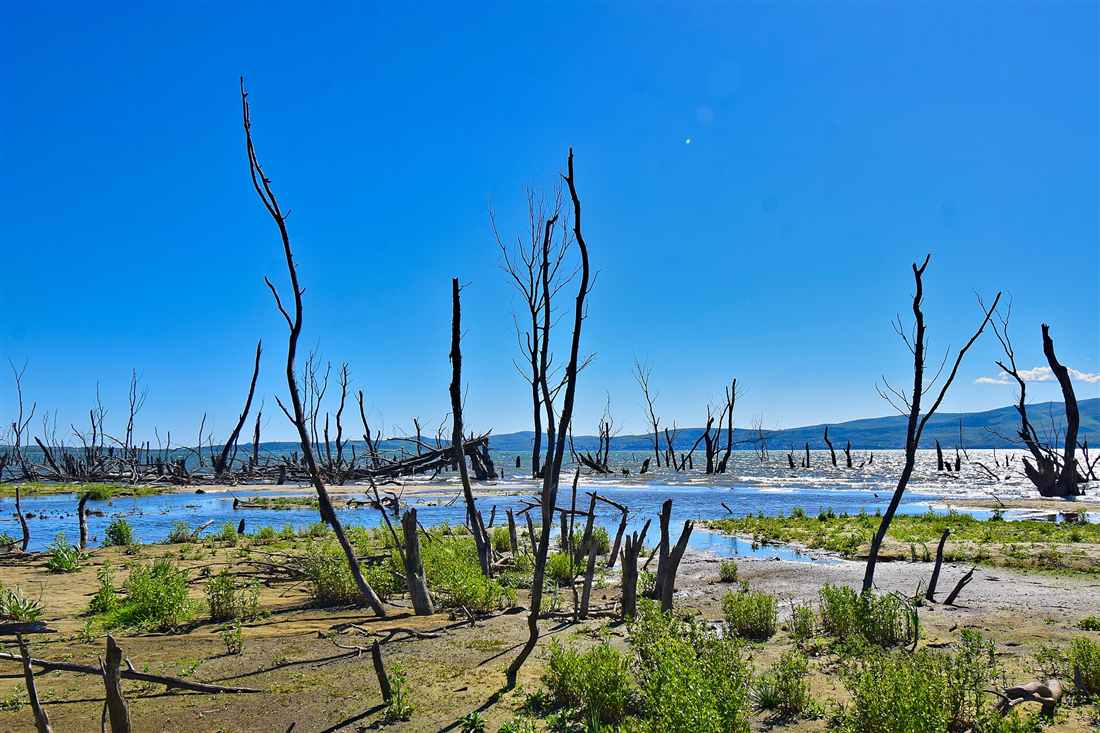
Kilkis tours cover the unit north of Thessaloniki: Kilkis town with its hill of Agios Georgios, the show cave and the war museum, Lake Doirani on the border with North Macedonia, the Doiran Memorial of the First World War, the Goumenissa wineries on Mount Paiko, the Axios valley and the salt lake of Pikrolimni. Plan the rest of the trip with Greece Tours.
This page covers the Kilkis tours you can arrange from Thessaloniki or Kilkis town, what the lake, the wine villages and the battlefields hold, the refugee kitchen of the unit, and how to plan the days by car.
What do Kilkis tours cover?
Kilkis tours cover the town of Kilkis with its hill of Agios Georgios, the show cave and the war museum, Lake Doirani on the border with North Macedonia, the wine villages of Goumenissa on Mount Paiko, the Axios valley, the salt lake of Pikrolimni and the battlefields of the Balkan Wars and the First World War.
Kilkis is the regional unit north of Thessaloniki, stretching from the Thessaloniki plain to the borders with North Macedonia and Bulgaria. It is farming country of wheat fields, dairy farms and vineyards, crossed by the Axios river in the west and closed by the Paiko, Belles and Krousia mountains on its edges.
Few foreign visitors reach it, which keeps the lake, the villages and the wine cellars quiet. The draw is a mix of nature, wine and modern history, with the front lines of two wars running through the unit.
- Kilkis town – the hill of Agios Georgios, the cave and the museums.
- Lake Doirani – the border lake shared with North Macedonia.
- Goumenissa – the wine town on the slopes of Mount Paiko.
- Axios valley – the river corridor from the border to the plain.
- Pikrolimni – the salt lake with its therapeutic mud.
- Battlefields – the sites of the Balkan Wars and the Macedonian front.
Our Macedonia tours page covers the wider region and the Serres tours page the unit to the east. Kilkis tours work as a day from Thessaloniki or two days from Kilkis town.
What do Kilkis tours see in Kilkis town?
Kilkis tours in the town see the hill of Agios Georgios with its church, park and monument to the fallen of 1913, the Kilkis cave under the hill, the war museum, the archaeological museum with the finds of the ancient Axios valley, and the cafés of the central square.
Kilkis is a young town in its present form. It burned in the Second Balkan War and was rebuilt afterwards, largely by Greek refugees from Asia Minor, Pontus and Eastern Thrace who settled the town and the villages around it. The centre is modern, with a pedestrian square and streets of shops and tavernas.
The hill of Agios Georgios rises above the town and holds its main sights: the church at the top, the monument to the soldiers of 1913, a pine park with paths and views over the plain, and the entrance to the cave on its slope.
- Agios Georgios hill – the church, the park and the town view.
- Monument of 1913 – the memorial to the soldiers of the battle of Kilkis.
- Kilkis cave – the show cave under the hill.
- War museum – the uniforms, weapons and maps of the battles.
- Archaeological museum – the finds of the ancient cities of the unit.
- Central square – the pedestrian heart of the town.
The hill, the cave and the museums sit within a short walk of each other. Kilkis tours cover the town in half a day.
What is the Kilkis cave?
The Kilkis cave is a limestone show cave inside the hill of Agios Georgios, with a walkway through chambers of stalactites and stalagmites, lit for visitors and kept at a steady cool temperature through the year, a short walk from the centre of Kilkis.
The cave formed as water dissolved the limestone of the hill, and the dripping water then built the columns, curtains and stalactites that fill its chambers. A path with railings and lighting runs through the main galleries, and guides lead the visits.
The cave is small next to the great show caves of Greece, and that is its appeal: the visit is short, close and quiet, and it fits between the hill park and the museums. The steady temperature makes it a cool stop in the heat of summer.
- Limestone chambers – the galleries inside the hill.
- Stalactites and stalagmites – the dripstone formations of the cave.
- Lit walkway – the railed path through the main galleries.
- Guided visits – the tours led by the cave staff.
- Cool temperature – the same climate inside in summer and winter.
- Hill setting – the entrance on the slope of Agios Georgios.
Kilkis tours pair the cave with the church and the monument on the hill above it.
What happened at the battle of Kilkis?
The battle of Kilkis was fought in June 1913 in the Second Balkan War, when the Greek army attacked the fortified Bulgarian lines at Kilkis and Lachanas, took the positions after three days of fighting with heavy losses, and opened the way north to the border of modern Greece.
The First Balkan War had driven the Ottomans out of Macedonia, and the allies then fell out over the division of the land. Bulgaria struck first, and the Greek army answered with an offensive from Thessaloniki. The Bulgarian army had fortified the hills around Kilkis, and the battle there was the largest and costliest Greek action of the war.
The town burned in the fighting. The victory at Kilkis and Lachanas decided the northern border of Greek Macedonia, and the town marks it every year with a memorial service on the hill of Agios Georgios.
- Second Balkan War – the war between the former allies over Macedonia.
- Kilkis and Lachanas – the two fronts of the battle.
- Three days of fighting – the assault on the fortified hills.
- Heavy losses – the costliest Greek battle of the war.
- Burned town – the Kilkis destroyed in the fighting.
- Annual memorial – the service on the hill of Agios Georgios.
The war museum in the town tells the story with maps, weapons and photographs. Kilkis tours visit it before the monument on the hill.
What do Kilkis tours see at Lake Doirani?
Kilkis tours at Lake Doirani see the southern third of a border lake shared with North Macedonia, the village of Doirani on its shore, the reed beds with herons and cormorants, the fishing boats, and the hills of the old Macedonian front rising behind the water.
Doirani is a shallow lake of about 43 square kilometres, with the larger part on the North Macedonian side and the southern shore in Greece. The Greek shore is quiet, with the village, a few tavernas serving the fish of the lake, and a lakeside path with views across the water to the town of Dojran on the far side.
The lake carries birds through the year, with herons, egrets, cormorants and ducks in the reeds and on the open water. Fishing has a long history here, and the tavernas cook carp, perch and the small fry of the lake.
- Border lake – the water shared with North Macedonia.
- Doirani village – the Greek settlement on the south shore.
- Reed beds – the herons, egrets and cormorants of the shore.
- Lake fish – carp, perch and small fry in the tavernas.
- Lakeside path – the walk along the Greek shore.
- Front-line hills – the ridges of the First World War.
Doirani lies about 40 km north of Kilkis town. Kilkis tours give it a half day with lunch by the water.
Which First World War sites do Kilkis tours visit?
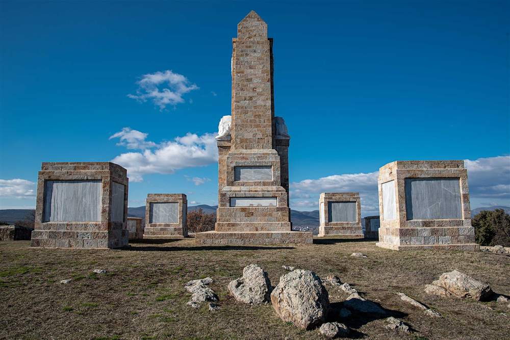
Kilkis tours visit the Doiran Memorial and the Doiran Military Cemetery near Lake Doirani, which honour the British soldiers of the Salonika campaign, the Greek monuments to the battles of Doiran and Skra-di-Legen, and the hills where the Macedonian front ran from 1915 to 1918.
The Macedonian front, also called the Salonika front, ran across the north of today’s Kilkis unit. British, French, Serbian and later Greek troops held the line against the Bulgarian army for three years, and the hills above Lake Doirani saw some of the hardest fighting of the campaign.
The Doiran Memorial stands on a hill near the lake and records the names of the British soldiers of the Salonika campaign who have no known grave. The cemetery beside it holds the graves of the soldiers who fell in the Doiran battles. The Greek army won its first major victory of the war at Skra-di-Legen in May 1918, and a monument marks the ridge near the village of Skra.
- Doiran Memorial – the monument to the missing of the Salonika campaign.
- Doiran Military Cemetery – the graves of the soldiers of the Doiran battles.
- Macedonian front – the line held from 1915 to 1918.
- Skra-di-Legen – the Greek victory of May 1918 near Skra.
- Allied armies – the British, French, Serbian and Greek forces.
- Battle of Doiran – the assaults on the Bulgarian lines above the lake.
The memorial and the cemetery lie a short drive from Doirani village. Kilkis tours combine them with the lake in one visit.
What do Kilkis tours see in Goumenissa and on Mount Paiko?
Kilkis tours in Goumenissa taste the PDO red wine of the Paiko slopes, made from Xinomavro blended with the local Negoska grape, visit the family wineries of the town, see the convent of the Panagia of Goumenissa, and walk into the beech and oak forests of Mount Paiko above.
Goumenissa is a small town on the eastern foothills of Paiko, and its vineyards hold one of the protected wine names of northern Greece. The Goumenissa blend softens the firm tannins of Xinomavro with the fruit of Negoska, a red grape grown almost nowhere else, and the result is a lighter, rounder red than the Xinomavro of Naousa.
Above the town, the villages of Paiko sit in forest at the edge of the mountain. The roads and paths lead to springs, chapels and viewpoints over the Axios valley, and the forest turns red and gold in autumn, the season of the grape harvest.
- Goumenissa PDO – the protected red wine of the Paiko slopes.
- Xinomavro – the firm red grape of northern Greece.
- Negoska – the local red grape of the Goumenissa blend.
- Family wineries – the cellars of the town and its villages.
- Panagia of Goumenissa – the convent near the town.
- Paiko forest – the beech and oak woods above the vineyards.
The Pella tours page covers the western side of Paiko. Kilkis tours book the wineries a day ahead, since the cellars are family-run.
Which ancient and Byzantine sites do Kilkis tours visit?
Kilkis tours visit the archaeological museum in the town, with the finds of the ancient cities of the Axios valley, the site of ancient Evropos on the river, and the Byzantine castle of Gynaikokastro on its hill above the plain, one of the fortresses that guarded the road north of Thessaloniki.
The ancient Axios valley was a route between the Aegean and the Balkans, and cities grew along it from the Iron Age onwards. Evropos stood on the river in the west of today’s unit, and excavations there have uncovered cemeteries and parts of the ancient town. The archaeological museum in Kilkis displays the finds from these sites, from pottery and weapons to sculpture.
Gynaikokastro, the castle of the woman, stands on a hill east of the Axios. The Byzantine emperor Andronikos III built it in the 14th century, and the local legend says it took its name from a woman who held it against its attackers. Its walls and towers still rise over the fields.
- Archaeological museum – the finds of the Axios valley cities.
- Ancient Evropos – the city on the Axios in the west of the unit.
- Axios route – the ancient road between the Aegean and the Balkans.
- Gynaikokastro – the 14th-century Byzantine castle on its hill.
- Castle legend – the woman who held the fortress.
- Plain views – the fields of Kilkis from the castle walls.
Kilkis tours reach Gynaikokastro by a short climb from the road and pair it with the museum on the same day.
What do Kilkis tours see along the Axios river?
Kilkis tours along the Axios see the longest river of Macedonia entering Greece at the Evzonoi border crossing, the towns of Polykastro and Axioupoli on its banks, the riverside woods of willow and poplar, and the farmland of the valley that runs south to the Thessaloniki plain.
The Axios rises in North Macedonia, where it is called the Vardar, and flows south through Kilkis to the Thermaic Gulf west of Thessaloniki. In the unit it is a wide river with gravel banks, riverside forest and farmland on both sides, and the motorway and the railway follow it north to the border.
Polykastro and Axioupoli face each other across the river and serve the farming villages of the valley. The riverside woods shelter birds and small wildlife, and the banks carry paths for walking and cycling away from the main roads.
- Axios river – the Vardar of North Macedonia, the longest river of the region.
- Evzonoi crossing – the main road border with North Macedonia.
- Polykastro – the market town on the east bank.
- Axioupoli – the town on the west bank below Paiko.
- Riverside woods – the willow and poplar forest of the banks.
- Valley farmland – the fields that run south to the plain.
Kilkis tours cross the Axios on the way from Kilkis to Goumenissa and stop at the river towns for coffee.
What is Pikrolimni, and why do Kilkis tours stop there?
Pikrolimni is a salt lake south of Kilkis town whose alkaline water and black mud are used for therapy, with a spa beside the shore where visitors bathe in the mud and water for the skin and the joints, and flat shores that draw water birds.
The name means bitter lake, after the taste of the mineral water. The lake is shallow and in the hot months the water drops and leaves a crust of salt and a bed of fine mud on its shores. The mud has been used for healing for generations, and the spa built beside the lake offers mud baths and treatments.
The flat, open shores make Pikrolimni a stop for birds as well. Waders feed in the shallows, and the lake sits in open farmland with wide views to the hills of the unit.
- Salt lake – the bitter, alkaline water that names it.
- Therapeutic mud – the black mud used for the skin and the joints.
- Lakeside spa – the baths and treatments on the shore.
- Salt crust – the white shores of the summer months.
- Water birds – the waders of the shallow lake.
- Open farmland – the fields around the lake.
Pikrolimni lies between Kilkis and Thessaloniki. Kilkis tours stop there on the drive to or from the city.
What do Kilkis tours eat and drink?
Kilkis tours eat the kitchen of the refugee families of Pontus, Asia Minor and Thrace, with Pontic pies, dumplings and dairy dishes, grilled meats of the town tavernas, fish from Lake Doirani, and cheeses and yoghurt from the dairy farms, with the red wine of Goumenissa at the table.
The refugees who rebuilt Kilkis brought their dishes with them, and the villages still cook them. The Pontic kitchen of the Black Sea coast is the strongest, with dough dishes, butter, cheese and corn, and the Asia Minor and Thracian families add spiced meats and syrup sweets.
Kilkis is dairy country, and its farms supply milk, cheese and yoghurt to Thessaloniki and beyond. The lake tavernas at Doirani serve the local fish, and the wineries of Goumenissa pour their reds with the meze.
- Pontic dishes – the dough, butter and cheese dishes of the Black Sea kitchen.
- Refugee pies – the pies of the Asia Minor and Thracian families.
- Grilled meats – the tavernas of the town and the villages.
- Doirani fish – carp and perch from the lake.
- Dairy – the milk, cheese and yoghurt of the Kilkis farms.
- Goumenissa wine – the red of Xinomavro and Negoska.
Kilkis tours eat in the town tavernas at night and at the lake or the wineries at lunch.
How do visitors reach Kilkis, and how do Kilkis tours plan the days?
Visitors reach Kilkis by road from Thessaloniki, 50 km south, with Thessaloniki airport the nearest, and by train on the line north from Thessaloniki. Kilkis tours plan one day for the town and Pikrolimni, a second for Doirani and the front, and a third for Goumenissa and the Axios.
A car is the practical way to cover the unit, since the lake, the wineries and the battlefields lie far apart on country roads. Thessaloniki works as a base for day trips, and Kilkis town and Goumenissa have hotels and guesthouses for a longer stay.
Spring and autumn suit the unit best, with green fields and birds in spring and the grape harvest and forest colours in autumn. Summer is hot on the plain but pleasant at the lake and on Paiko, and winter brings fog to the valleys.
- Thessaloniki to Kilkis – 50 km, about 45 minutes.
- Kilkis to Doirani – about 40 km north.
- Day one – Kilkis town, the cave, the museums and Pikrolimni.
- Day two – Lake Doirani, the Doiran Memorial and Skra.
- Day three – Goumenissa, Paiko, Gynaikokastro and the Axios.
- Where to stay – Kilkis town, Goumenissa or Thessaloniki.
Kilkis tours join the Serres and Pella units for a longer route through central Macedonia.
Frequently Asked Questions
Where is Kilkis?
In central Macedonia, 50 km north of Thessaloniki, bordering North Macedonia and Bulgaria, with Serres to the east and Pella to the west.
What is Lake Doirani?
A shallow border lake of about 43 square kilometres, shared with North Macedonia, with the Greek village of Doirani and the Doiran Memorial on its southern side.
What wine is made in Kilkis?
The PDO red of Goumenissa, a blend of Xinomavro and the local Negoska grape, grown on the slopes of Mount Paiko.
What happened at Kilkis in 1913?
The Greek army defeated the Bulgarian army at Kilkis and Lachanas in the Second Balkan War, after three days of fighting that destroyed the town.
Can Kilkis be visited as a day trip from Thessaloniki?
Yes. Kilkis town and Pikrolimni fit in half a day, and Lake Doirani or Goumenissa each fill a full day by car.
When is the best time for Kilkis tours?
Spring for the green fields and the birds of the lakes, and autumn for the grape harvest in Goumenissa and the forest colours of Paiko.